


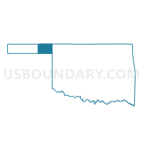
Voting District 13, Beaver County, Oklahoma
About
Outline

Summary
| Unique Area Identifier | 653497 |
| Name | Voting District 13 |
| County | Beaver County |
| State | Oklahoma |
| Area (square miles) | 322.99 |
| Land Area (square miles) | 320.74 |
| Water Area (square miles) | 2.24 |
| % of Land Area | 99.31 |
| % of Water Area | 0.69 |
| Latitude of the Internal Point | 36.89218650 |
| Longtitude of the Internal Point | -100.18922760 |
Maps


Graphs
Select a template below for downloading or customizing gragh for Voting District 13, Beaver County, Oklahoma


Neighbors
Neighoring Voting District (by Name) Neighboring Voting District on the Map
- Voting District 101, Harper County, OK
- Voting District 11, Beaver County, OK
- Voting District 23, Beaver County, OK
- Voting District 25, Beaver County, OK
- Englewood Township Voting District, Clark County, KS
- Odee Township Voting District, Meade County, KS
- Sand Creek Township Voting District, Meade County, KS
Top 10 Neighboring County Subdivision (by Population) Neighboring County Subdivision on the Map
- South Beaver CCD, Beaver County, OK (2,938)
- North Beaver CCD, Beaver County, OK (2,698)
- Laverne CCD, Harper County, OK (1,967)
- Englewood township, Clark County, KS (125)
- Sand Creek township, Meade County, KS (38)
- Odee township, Meade County, KS (37)
Top 10 Neighboring Place (by Population) Neighboring Place on the Map
Top 10 Neighboring Unified School District (by Population) Neighboring Unified School District on the Map
- Laverne Public Schools, OK (2,407)
- Meade Unified School District 226, KS (2,240)
- Beaver Public Schools, OK (1,876)
- Ashland Unified School District 220, KS (1,229)
- Forgan Public Schools, OK (784)
Top 10 Neighboring State Legislative District Lower Chamber (by Population) Neighboring State Legislative District Lower Chamber on the Map
Top 10 Neighboring State Legislative District Upper Chamber (by Population) Neighboring State Legislative District Upper Chamber on the Map
Top 10 Neighboring 111th Congressional District (by Population) Neighboring 111th Congressional District on the Map
Top 10 Neighboring Census Tract (by Population) Neighboring Census Tract on the Map
- Census Tract 9666, Meade County, KS (2,751)
- Census Tract 9516, Beaver County, OK (2,698)
- Census Tract 9671, Clark County, KS (2,215)
- Census Tract 9522, Harper County, OK (1,967)
- Census Tract 9517, Beaver County, OK (1,327)
Top 10 Neighboring 5-Digit ZIP Code Tabulation Area (by Population) Neighboring 5-Digit ZIP Code Tabulation Area on the Map
- 67864, KS (2,227)
- 73848, OK (2,156)
- 73932, OK (2,092)
- 73938, OK (781)
- 73844, OK (269)
- 73855, OK (106)